

The three new moons will be in low Earth orbit (LEO) at 500 km., about 80 km. above where the International Space Station soars. These satellites will be made of mirror-like reflective materials, and the report cites state media that they’ll be “eight times brighter than the real moon and will light up an area with the diameter of 10 to 80 km. (49.7 miles).”
The chairman of Chengdu Aerospace Science and Technology Microelectronics System Research Institute, Wu Chunfeng, said the three artificial moons would operate alternately, only one lighting the streets at a time, providing “a dusk-like glow” over 50 square km. The overall illumination would be about one-fifth the brightness of streetlights.
The savings to the city is estimated at 1.2 billion yuan ($240 million) a year in electrical costs. And along with the savings, there would be a beneficial reduction of pollution, both from the plants producing electricity as well as the current light pollution from the streetlights.
The planners also foresee using the three satellites to illuminate rural areas and areas struck by earthquakes or hurricanes, or where conventional power has been interrupted.
The new moons will join the thousands of other orbiting devices already gathering scientific research, guiding our GPS systems, and maintaining massive flows of communication data.
CROWDED SKIES
The number of satellites already circling the planet, stacked at four altitude levels, is accelerating each year. A brief review of the who, what, where, when, how many, and why might help us appreciate the increasing congestion that, to the unaided eye, remains invisible.
What: NASA has a rather straightforward definition for airborne satellites. “A satellite is a moon, planet, or machine that orbits a planet or star.” We’ll stick to just the manufactured vehicles.
Where: The thousands of satellites orbiting around the Earth are stacked up in four defined altitudes. Most of them (62.9%) are in low Earth orbits (LEO), ranging from 250 km. to 1,500 km. Above LEO are the satellites in medium Earth orbit, anywhere between 8,000 km. and 24,000 km., where 5.9% of the traffic flows. Next are those in GEO or geostationary Earth orbits, which are just under 36,000 km. The fourth level is different because of its deflection, curving elliptically rather than in a generalized circle around the Earth. This is the elliptical orbit level, and it can range from less than 1,000 km. to more than 40,000 km. above the surface of the seas and land. There are different advantages and problems at the different levels depending on the type of satellite sent into orbit.
Who and When: The first successful manufactured satellite was launched more than a half century ago. Sputnik 1 was sent into orbit in 1957. It shocked the world and kickstarted the American space program.
How Many: In 2018, according to UNOOSA (United Nations Office for Outer Space Affairs), 4,857 satellites are currently orbiting the planet. That number represents an increase of 4.79% compared to last year. Not all of these satellites are still working. Among those now counted as space trash is the oldest vessel still aloft. It was launched in 1958, and it long ago gave up any useful functioning.
The UCS (Union of Concerned Scientists) keeps track of the current operational satellites, and that number currently is only 1,980. That means there are 2,877 pieces of junk still orbiting at high speeds in the lower atmospheres.
Of the 453 objects launched in 2017, only 390 were still in space at the end of April 2018. The remainder either were purposely brought back down, or they fell out and burned up in the atmosphere with parts occasionally making it back to Earth.
Why: What is all this flying hardware doing up there? Some of it is very familiar, like the GPS on your phone or tablet looking for and reading signals from space, and a lot of it is designed to stream scientific data back to companies, countries, and universities. We’ll look first at the categories by purpose and then by users.
- Communications: 792 satellites
- Earth observation: 66 satellites
- Technology development/demonstration: 213 satellites
- Navigation/positioning: 121 satellites
- Space science/observation: 76 satellites
- Earth science: 23 satellites
Broken down by types of users, there are four categories here:
- Commercial users: 826
- Government users: 523
- Military users: 399
- Civil users: 138
The number of countries that have launched satellites has now reached 81. And if you’re wondering how the almost 5,000 vehicles avoid each other, one contributing factor is that almost 58% of these are in sun-synchronous orbits, which means they pass the equator at the same time each day. That predictability makes the sky safer than if the orbits were constantly changing. You can find a variety of satellite-tracking apps that will show you when some of the more important ships are passing overhead.
In the photo is the Askari satellite, and the Apple app called Satellite Tracker indicates that it will be passing over IMA's office here in Montvale, N.J., 44 minutes from the time this article was written.
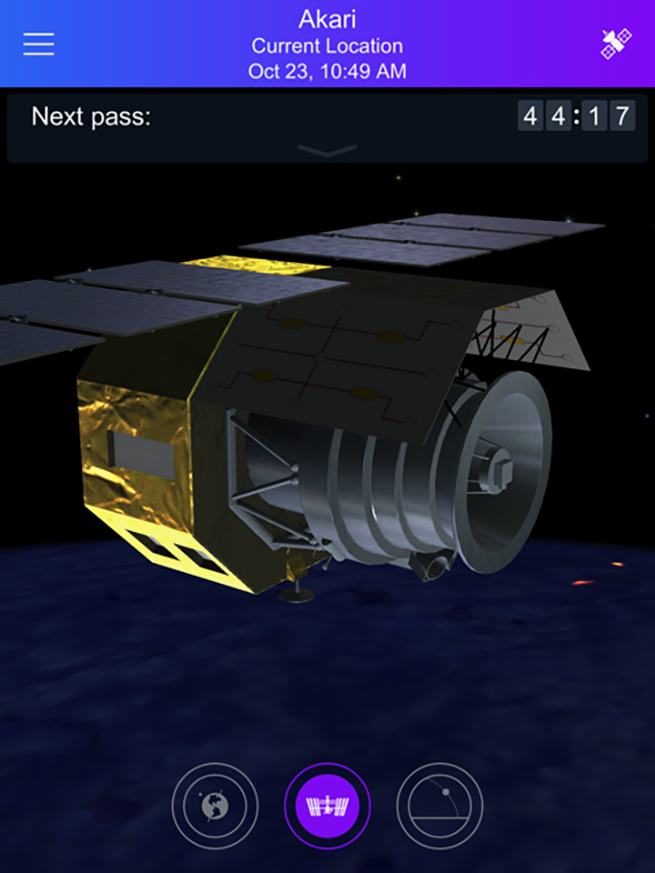
The Askari is an infrared astronomy satellite that was created by Japan Aerospace Exploration Agency. It’s been aloft for about 12 years, and it’s big, weighing in at over a ton. I chose the button that shows a three-dimensional view of the craft, and the other two, at the bottom of the screen, display the relative position of its orbit looking down at the Earth’s surface. The other looks skyward and shows what you would see looking up at the stars from the top of the satellite.
LARGEST AND SMALLEST
Although Earth satellites vary wildly in size, from something that would rest comfortable in your hand to the International Space Station or Hubble Telescope, they are all subject to the same rules of physics. If you want your lab up there to slow down, you push it up into a higher orbit—faster, you drop it down to a lower orbit.
For a comparison, here are the two extremes, not only in size but also in cost. The Kalam Satellite is unofficially the smallest satellite. It was sent up to measure radioactivity in the atmosphere and was produced by high-school students in India who used a 3-D printer to create the carbon-fiber shell and embed a nano Geiger meter within to collect the data. It was launched by NASA in June 2017 from Wallops Island, Va.
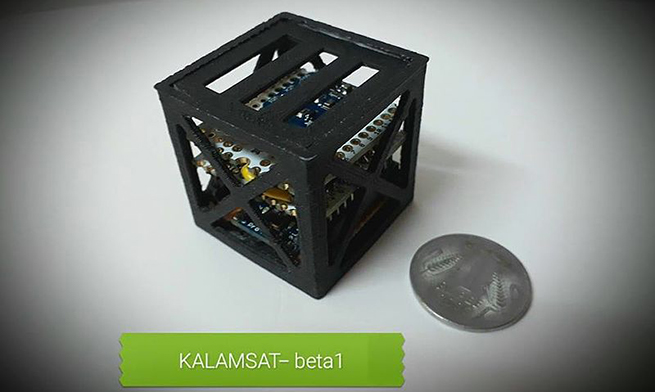
Kalam Satellite beside a 1-rupee coin. Photo by Riyadh Sharon/ Creative Commons
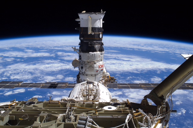
While the Kalam SAT weighed 64 grams, the ISS (International Space Station) took a little more thrust to place in orbit as perhaps the most famous habitable artificial satellite. For almost 20 years, its 925,000 pounds has circled the planet every hour and a half.
International Space Station satellite photo courtesy of NASA
If the new Chinese moons are successfully positioned in orbit in 2020, they will join the traffic in relatively low orbit, adding to what is a growing catalog of human curiosity and accomplishment, visible even from space.

