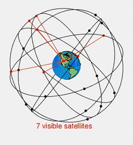
The first two were maps and mechanical clocks. Today, advanced versions of those two inventions cohabit in the teams of satellites that soar over-head in medium-Earth orbit, providing us with navigation and incredibly accurate time signals.
Carr writes, “What the map did for space—translate a natural phenomenon into an artificial and intellectual conception of that phenomenon—another technology, the mechanical clock, did for time.” Today, the clocks in the global positioning satellites are atomic, and the location points are sent down via radio waves—and the two combine to feed maps to our cars, measure the depths of the seas, assist cellular networks, and time-stamp our online banking transactions.
GLOBAL NAVIGATION SYSTEMS
These satellites continuously locate positions and update mapping while also serving as a master clock in space for those below scheduling taxi fleets or time-stamping bank transactions. There are currently five positioning and navigation satellite systems flying over the planet. The United States has its GPS system with 31 satellites, the Russian GLONASS has 24, the European Union’s Galileo system has 26, China’s Beidu has 22, and India’s NavIC has seven. The orbits are approximately 11,000 miles up, and the streaking satellites circle the planet twice each day. That sounds like a lot of hardware in constant motion, but the numbers are insignificant compared alongside the 8,261 other individual craft in circular orbits doing other things, like internet and surveillance, according to the latest count of satellites by UNOOSA (United Nations Office for Outer Space Affairs).
The accuracy of the navigation and timekeeping on the current Galileo system is impressive. The satellites offer a positioning accuracy to less than one meter, which make them more precise than the three meters of the GPS satellites, and the hydrogen maser clock on board the Galileo craft, also called the hydrogen frequency standard, will only be off in its time calibration by one second every 30 million years.
The navigation offered by current navigational satellite systems like GPS is useful for ordinary cars, as well as autonomous vehicles, and for other services like cellular networks, banking systems, financial markets, and power grids connected for precise time synchronization.
Like ancient mariners, GPS users look to the sky, often with handheld receivers, but instead of marking their location relative to constellations, the modern traveler listens for satellites. Actually, their devices do the listening, and, along with computers, they trilaterate the relationship of their points of reference with the locations of at least three other moving points (satellites). Doing the math with all the variables in motion is pretty impressive. And now, with a recent development from researchers at Delft University of Technology in the Netherlands, the accuracy has been narrowed to the width of a human hand in a new system that has come down to Earth.
SUPER GPS
On November 16, 2022, Delft University published the results of its alternative positioning system in the journal Nature. One significant advancement of the system is its accuracy down to 10 cm (3.937"). Another is that the equipment for sensing and triangulation is installed on the ground. That eliminates expensive launches and the problem of possible impact with space debris or other airborne vehicles, and it provides a reliable backup system.
The working prototype has been dubbed Super GPS for its accuracy and ability to optimally function in environments where weak satellite radio signals can be blocked or confused by buildings or other obstructions, producing errors of up to several meters. The superior performance of the Delft GPS is enabled “through a constellation of radio transmitters, connected and time-synchronized at the subnanosecond level through a fibre-optic Ethernet network, using optical and wireless transmission schemes similar to those encountered in mobile communication networks.” Unlike satellites that each have an atomic clock, there’s a general atomic clock to which each land-based Delft receiver is connected via fiber-optic cables.
Started in 2016, the Delft Super GPS project involved faculty from electrical engineering, mathematics and computer science, civil engineering and geosciences, along with faculty from the Department of Physics at Vrije Universiteit. Ultimately, it isn’t intended as a replacement for conventional GPS; rather, it could provide improved accuracy in city environments and serve as a backup system in the event of a temporary failure of the satellite system already in place. Maintaining the satellite systems is important because new uses for GPS are constantly being discovered, including measuring earthquakes, monitoring volcanoes, checking water levels, and even analyzing the atmosphere for density of electrically charged particles or amounts of water vapor.

January 2023


